Wednesday, January 19, 2011
HOME
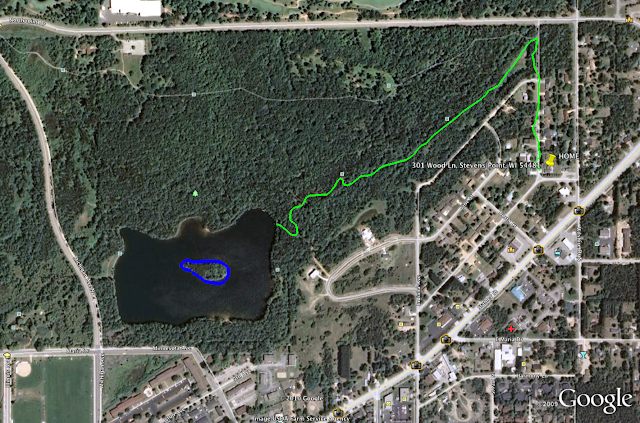
The yellow pin marks my house in Stevens Point, WI. The wooded area is Schmeekle reserve where the University in Stevens Point owns and has quarantined into their own wildlife preservation. No hunting or motorized vehicles allowed in the forest there. They do allow you to fish though, and even though there wasn't a beach, it was never a problem when a few of us went for a swim. Some people don't like lake water, personally I love it. I don't mind a few weeds on the feet haha. The green path shows the bike or walk path i used to take when I wanted to go from home to the lake. I would just to get out of the house or if I needed somewhere to think. My friends and I had a small paddle boat hidden in the bushes near the lake and would paddle out to the island. I won't post what went on out there, but you can make your own assumptions haha. We had a lot of fun though. I go back to the lake and make a trip out to the island by myself every time I get to go back home. Brings back some good memories :)
Choropleth map of the 2009 Unemployment Rates in Wisconsin
This is a Choropleth map of Wisconsin showing the unemployment rates in WI for 2009. It's not as bad as most other states, but that's probably just because it isn't quite as populated as other states. The boundaries on there are counties, and there are only 4 of them with higher than a 10% unemployment rate. Tht's pretty good compared to some of the bigger cities in the US.
Topographical Map of Wisconsin (Elevation)
This is a topographical map of Wisconsin. The main river running through the center of the state is the Fox River (the only river to flow North other than the Nile). As you can see, the further North you go, the higher the elevation becomes. To the east the elevation is lowest where the state meets Lake Michigan (the shoreline).
Subscribe to:
Posts (Atom)


