Monday, April 25, 2011

Monday, April 18, 2011

Excavating the Mounds

It wasn't until the 1930's when it was decided to excavate the mounds. Under President Roosevelt the WPA (Works Progress Administration), sent in a professional team. They dug up pieces of several different mounds and were shocked with some of their discoveries. The architecture of some mounds showed that the people were not only very civilized, but also very intelligent. They had used the different soil types (clay in particular) to construct the sturdy and lasting mounds that we still see today. Also, the team in the 30's dug up some artifacts that contributed to the knowledge that the people there were somewhat sophisticated as well. The excavation team later realized after digging up several sets of human bones that at least one of the mounds was a burial mound. The pictures below are of the Great Temple Mound and of some artifacts that were dug up during the excavations.

Great Temple Mound


Ancient artifacts

Tuesday, March 29, 2011

WATER - How were the Great Lakes formed?


Having grown up in Wisconsin, I've heard a lot about the Great Lakes. That being said, a new question was brought to mind during class the other day. In class we were learning about how lakes were formed, and that made me wonder what it was that carved out these massive lakes. 

http://www.greatlakesnorthamerica.com/howthegreatlakes.html

The site above is what I used to find my information.

According to this site, the primary cause for the formation of these lakes is glacial erosion. Around 14,000 years ago, the Lauren Tide (a mass of glaciers covering most of Canada and northern parts of the US), started to shift to the South as the climate warmed and they continued to melt and refreeze. Eventually the glaciers carved out the massive indentations that would slowly (via rain and the glacier melting as it passed) fill with water and become the Great Lakes that we now know.

Monday, March 7, 2011

EXTREMOPHILES

THERMOPHILES

Found in geothermally heated regions of the earth, Thermophiles can survive between 115 and 175 degrees Fahrenheit. They can be found in hot springs like those in Yellowstone National Park.


ACIDOPHILES

Like thermophiles, acidophiles can survive in extreme conditions. Their specialty isn't necessarily heat though. They can survive in extremely acidic conditions. Most of the time with a pH level of 2.0 or below. They are usually bacteria type organisms.


HALOPHILES

Like the other 2, halophiles are also usually bacteria type organisms. They can survive in extremely salty conditions. In comparison, most similar type organisms would dissolve or not be able to function properly in such salty conditions. They are very prominent in salty bodies of water like the Great Salt Lake in Utah.

Monday, February 28, 2011

GEOLOGY

3 main types of Rocks - IGNEOUS, SEDIMENTARY, METAMORPHIC

Igneous Rocks are formed when molten lava cools and hardens over time (also known as intrustive igneous rock), or when the crust meets the mantle and previous content is melted and hardened into rock (extrusive). Examples: Pumice and granite

Pumice


Sedimentary rock is formed by the collection of rocks and materials at the surface of the earth and in bodies of water. Typically the layers in sedimentary rock makes it easy to tell how it was formed and over how long it took to form. Examples: sandstone and chalk

Sandstone


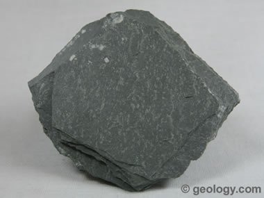
Metamorphic rocks are exactly what they sound like, rocks that have mophed into something new. Either  igneous, sedimentary or older metamorphic rock, under extreme pressure and heat and be caused to change both physically and chemically. Once a rock changes its form like this, it is considered a metamorphic rock. Examples: Marble, which is metamorphosed limestone and Slate, which is metamorphosed from shale or silts.

Slate

SOILS

Link: The 12 Soil Orders of the World

Georgia's soil is most well-known for it's kaolin clay production. It is also rich in marble, barite and bauxite. (Georgia Soil and Rock content)

As far as the soil orders goes, there is an abundance in ultisols, inceptisols, and alfisols.
(Georgia Soil Orders)

Georgia Soil can be rich in clay, hence the redish color to this Georgia soil image sample.

You can identify a soil by its color. Typically, depending on the soils contents, the color and "chroma" can help you identify what type of soil it is. The most commonly used source for soil identification is the Munsell Soil Color Chart (Munsell Soil Chart Online)

The following images are maps of the soil regions in Georgia. Because of the fact that Georgia has both a coastline and a mountain line on either side, the soil types can be very different on either side of the state.


LINK: Soil Texture Dichotomous Key

Tuesday, February 8, 2011


This is an image of the route traveled during our geocaching experiment. Each of the angles is where 1 of the 8 total destinations were. After the walk was over, google earth estimated the distance walked at 0.26 miles. I will say that it is slightly more than that, considering that the route I drew on the computer is cutting corners between pinpoints.

Link: Geocaching Website

Geocaching is a fun way to get outside, off your feet, and do some natural environment adventuring. There are geocaches (or destinations with placed objects) all over the world, marked out by GPS. If you're ever in the mood for a real life treasure hunt or just some fun walking around, then geocaching is a cool way of recording your findings. You can even go onto the website I linked to above and blog or post about your findings and see what others had to say about those very same locations! I think going on a neat little geocaching adventure would make for a good date, and maybe, if your smart, you'll make the last destination a romantic one with a Valentine's Day gift waiting. "Tis the season.

Wednesday, February 2, 2011


My favorite animal is the Wolf. Wolves have just always seemed to symbolize so many things: closeness to their family (I love the pack), toughness, the ability to survive at all costs (I consider myself a bit of a lone wolf, respect for the pack, but very independent), and there's just a majestic image about them too. I think they're absolutely beautiful animals. Hearing wolves howling from a far just gives me the chills. I've always had a huge respect for native americans and their heritage as well, and the wolf plays a huge role in that. There are some pretty cool folk tales that involve wolves that I remember being very fond of growing up.


In Blue Mounds, WI, there is what some might consider the most beautiful caves in upper Midwest. I've been there once, but I was too young to vividly remember. It's been named a National Landmark and thousands of tourists come annually to walk the caves. There are giant stalagmites and columns that can simply blow your mind if you've never been inside a large cave before.

Cave of the Mounds
This is a link to the Granite Peak Ski Resort. The resort is on the Rib Mountain State Park, but I couldn't find the park's website. I used to go snowboarding there a lot when I was younger. It's about 45 minutes from my home. I can't ever recall being there when it wasn't the winter time, so skiing is the only thing I've ever done there. That being said, I know in high school some classes took trips there and saw the actual environmental park side of the mountain (so I know it's not just a myth haha). But regardless it's very beautiful up there. I look forward to going back sometime when I'm done with school and basketball.

Granite Peak Skiing

LSRS - Linwood Springs Research Station


LSRS is a research station a few minutes from my house back home in Wisconsin. It's on the outskirts of town and I had never actually heard of it until I was a freshman in high school. My friend lives near the place and we saw it one day in passing on our bikes. At first we didn't know what it was because it was hard to see from the road, but then we did some research on the net and found out soon enough that it was a research station that specializes in studying red-shouldered hawks, northern saw-whet owls, and sharp shinned hawks.

Linwood Springs Research Station

Wednesday, January 19, 2011

HOME


The yellow pin marks my house in Stevens Point, WI. The wooded area is Schmeekle reserve where the University in Stevens Point owns and has quarantined into their own wildlife preservation. No hunting or motorized vehicles allowed in the forest there. They do allow you to fish though, and even though there wasn't a beach, it was never a problem when a few of us went for a swim. Some people don't like lake water, personally I love it. I don't mind a few weeds on the feet haha. The green path shows the bike or walk path i used to take when I wanted to go from home to the lake. I would just to get out of the house or if I needed somewhere to think. My friends and I had a small paddle boat hidden in the bushes near the lake and would paddle out to the island. I won't post what went on out there, but you can make your own assumptions haha. We had a lot of fun though. I go back to the lake and make a trip out to the island by myself every time I get to go back home. Brings back some good memories :)

Choropleth map of the 2009 Unemployment Rates in Wisconsin


This is a Choropleth map of Wisconsin showing the unemployment rates in WI for 2009. It's not as bad as most other states, but that's probably just because it isn't quite as populated as other states. The boundaries on there are counties, and there are only 4 of them with higher than a 10% unemployment rate. Tht's pretty good compared to some of the bigger cities in the US.

Topographical Map of Wisconsin (Elevation)

This is a topographical map of Wisconsin. The main river running through the center of the state is the Fox River (the only river to flow North other than the Nile). As you can see, the further North you go, the higher the elevation becomes. To the east the elevation is lowest where the state meets Lake Michigan (the shoreline).